
Thank you for supporting this site ❤️
Make a donation
Make a donation
Vicente Suarez topographic map
Click on the map to display elevation.
Thank you for supporting this site ❤️
Make a donation
Make a donation
About this map
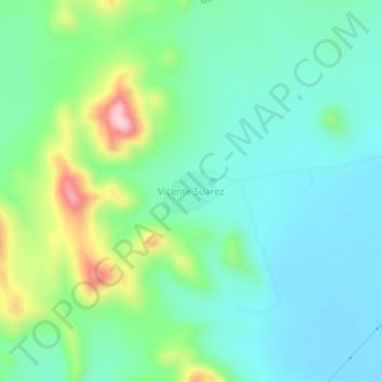
Name: Vicente Suarez topographic map, elevation, terrain.
Location: Vicente Suarez, Municipio de Durango, Durango, México (24.32061 -104.46506 24.36061 -104.42506)
Average elevation: 1,955 m
Minimum elevation: 1,887 m
Maximum elevation: 2,151 m
Thank you for supporting this site ❤️
Make a donation
Make a donation
Other topographic maps
Click on a map to view its topography, its elevation and its terrain.
Jardines de Cancun
México > Durango > Municipio de Durango > Victoria de Durango
Average elevation: 1,877 m
Presa Guadalupe Victoria
México > Durango > Municipio de Durango > El Durazno
Average elevation: 2,161 m
Jardin Nueva Vizcaya
México > Durango > Municipio de Durango > Victoria de Durango
Average elevation: 1,888 m
Parque Guadiana
México > Durango > Municipio de Durango > Victoria de Durango
Average elevation: 1,914 m
Thank you for supporting this site ❤️
Make a donation
Make a donation