
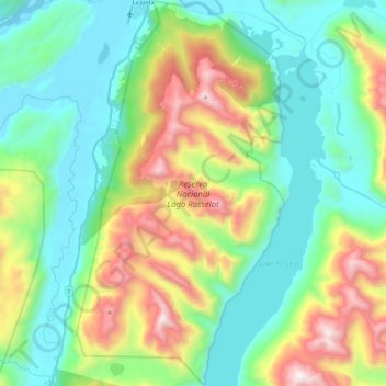
Reserva Nacional Lago Rosselot topographic map
Interactive map
Click on the map to display elevation.
About this map
Name: Reserva Nacional Lago Rosselot topographic map, elevation, terrain.
Average elevation: 494 m
Minimum elevation: 24 m
Maximum elevation: 1,586 m
Other topographic maps
Click on a map to view its topography, its elevation and its terrain.
Parque Nacional Queulat
Chile > Región Aysén del General Carlos Ibáñez del Campo > Provincia de Aysén > Cisnes
Parque Nacional Queulat, Cisnes, Provincia de Aysén, Región Aysén del General Carlos Ibáñez del Campo, 6010000, Chile
Average elevation: 772 m
Melimoyu
Chile > Región Aysén del General Carlos Ibáñez del Campo > Provincia de Aysén > Cisnes
Melimoyu, Cisnes, Provincia de Aysén, Región Aysén del General Carlos Ibáñez del Campo, Chile
Average elevation: 170 m
Puerto Raúl Marín Balmaceda
Chile > Región Aysén del General Carlos Ibáñez del Campo > Provincia de Aysén > Cisnes
Puerto Raúl Marín Balmaceda, Cisnes, Provincia de Aysén, Región Aysén del General Carlos Ibáñez del Campo, Chile
Average elevation: 26 m
Puyuhuapi
Chile > Región Aysén del General Carlos Ibáñez del Campo > Provincia de Aysén > Cisnes
Puyuhuapi, Cisnes, Provincia de Aysén, Región Aysén del General Carlos Ibáñez del Campo, Chile
Average elevation: 229 m