
Griebal topographic map
Interactive map
Click on the map to display elevation.
About this map
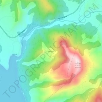
Name: Griebal topographic map, elevation, terrain.
Average elevation: 665 m
Minimum elevation: 506 m
Maximum elevation: 1,009 m
Other topographic maps
Click on a map to view its topography, its elevation and its terrain.
Aínsa
Spanje > Aragón > Sobrarbe > Aínsa-Sobrarbe/L´Aínsa-Sobrarbe
Aínsa, Aínsa-Sobrarbe/L´Aínsa-Sobrarbe, Sobrarbe, Huesca, Aragón, 22330, Spanje
Average elevation: 596 m