
Thank you for supporting this site ❤️
Make a donation
Make a donation
Soestduinen topographic map
Click on the map to display elevation.
Thank you for supporting this site ❤️
Make a donation
Make a donation
About this map
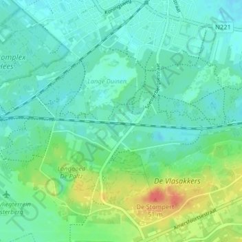
Name: Soestduinen topographic map, elevation, terrain.
Location: Soestduinen, Soest, Utrecht, Nederland, 3768 MJ, Nederland (52.12541 5.27619 52.16541 5.31619)
Average elevation: 14 m
Minimum elevation: 1 m
Maximum elevation: 50 m
Thank you for supporting this site ❤️
Make a donation
Make a donation
Other topographic maps
Click on a map to view its topography, its elevation and its terrain.