
Réservoir Pipmuacan topographic map
Interactive map
Click on the map to display elevation.
About this map
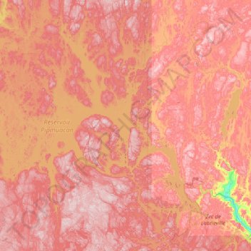
Name: Réservoir Pipmuacan topographic map, elevation, terrain.
Average elevation: 478 m
Minimum elevation: 136 m
Maximum elevation: 702 m
Other topographic maps
Click on a map to view its topography, its elevation and its terrain.
Lac Archer
Canada > Québec > Mont-Valin
Lac Archer, Mont-Valin, Le Fjord-du-Saguenay, Saguenay–Lac-Saint-Jean, Québec, Canada
Average elevation: 577 m
Lac La Sorbière
Canada > Québec > Mont-Valin
Lac La Sorbière, RO201, Mont-Valin, Le Fjord-du-Saguenay, Saguenay–Lac-Saint-Jean, Québec, Canada
Average elevation: 538 m
Lac Orignal
Canada > Québec > Mont-Valin
Lac Orignal, Mont-Valin, Le Fjord-du-Saguenay, Saguenay - Lac-Saint-Jean, Québec, Canada
Average elevation: 580 m
Lac Morel
Canada > Québec > Mont-Valin
Lac Morel, Mont-Valin, Le Fjord-du-Saguenay, Saguenay - Lac-Saint-Jean, Québec, Canada
Average elevation: 360 m