
Make a donation
Menifee topographic map
Click on the map to display elevation.
Make a donation
Menifee
The city is centrally located in Southern California in the Menifee Valley. It is almost 15 miles (24 km) north of Temecula and just north of Murrieta. Menifee is roughly 46 square miles (100 km2) in size and has an elevation of 1,424 feet (434 m). The incorporated City of Menifee includes the communities of Sun City, Quail Valley, and Romoland.
Make a donation
About this map
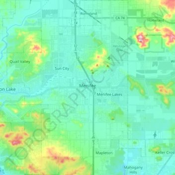
Name: Menifee topographic map, elevation, terrain.
Location: Menifee, Riverside County, California, United States (33.61164 -117.25814 33.75775 -117.11884)
Average elevation: 474 m
Minimum elevation: 407 m
Maximum elevation: 773 m
Make a donation
Other topographic maps
Click on a map to view its topography, its elevation and its terrain.
Temescal Creek
United States > California > Riverside County > Temescal Valley
Average elevation: 317 m