
Thank you for supporting this site ❤️
Make a donation
Make a donation
Perry topographic map
Click on the map to display elevation.
Thank you for supporting this site ❤️
Make a donation
Make a donation
About this map
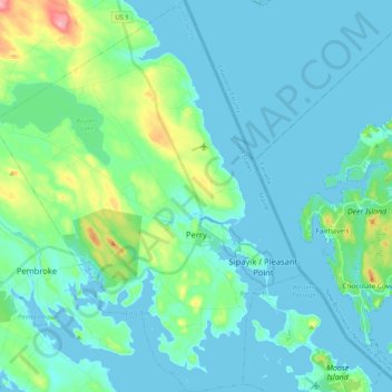
Name: Perry topographic map, elevation, terrain.
Location: Perry, Washington County, Maine, United States (44.90797 -67.18585 45.05542 -67.01976)
Average elevation: 18 m
Minimum elevation: -3 m
Maximum elevation: 113 m
Thank you for supporting this site ❤️
Make a donation
Make a donation
Other topographic maps
Click on a map to view its topography, its elevation and its terrain.
Thank you for supporting this site ❤️
Make a donation
Make a donation
Saint Croix Island International Historic Site
United States > Maine > Washington County > Calais
Average elevation: 6 m
Thank you for supporting this site ❤️
Make a donation
Make a donation
Thank you for supporting this site ❤️
Make a donation
Make a donation