Geolocate

Prince Edward County topographic map

Interactive map

Click on the map to display elevation.

About this map

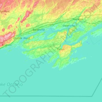
Name: Prince Edward County topographic map, elevation, terrain.

Location: Prince Edward County, Central Ontario, Ontario, Canada (43.79817 -77.62793 44.18552 -76.49975)

Average elevation: 96 m

Minimum elevation: 70 m

Maximum elevation: 260 m

Other topographic maps

Click on a map to view its topography, its elevation and its terrain.

London

Canada > Ontario

Average elevation: 269 m

Omemee

Canada > Ontario > Kawartha Lakes

Average elevation: 266 m

Corunna

Canada > Ontario > Lambton County > St. Clair

Average elevation: 190 m

Port Elgin

Canada > Ontario > Bruce County

Average elevation: 199 m

McNicoll Park

Canada > Ontario > Toronto

Average elevation: 177 m

Kingston

Canada > Ontario > Kingston

Average elevation: 94 m

Jamestown

Canada > Ontario > Huron County > Huron East

Average elevation: 339 m

Auburn

Canada > Ontario > Huron County > Central Huron

Average elevation: 292 m

Exeter

Canada > Ontario > Huron County > South Huron

Average elevation: 268 m

Robinson's Bay

Canada > Ontario > Sudbury District > Killarney

Average elevation: 194 m

Warwick

Canada > Ontario > Lambton County

Average elevation: 220 m

Hanmer

Canada > Ontario > Sudbury District > Greater Sudbury

Average elevation: 295 m

Kawartha Lakes (city)

Canada > Ontario

Average elevation: 274 m

St. Johns

Canada > Ontario

Average elevation: 205 m

Cambridge

Canada > Ontario > Cambridge

Average elevation: 295 m

Georgetown

Canada > Ontario > Halton Region

Average elevation: 255 m

Millbrook

Canada > Ontario > Peterborough County > Cavan-Monaghan

Peterborough's topography is largely defined by land formations created by the receding Wisconsian glaciers 10,000–15,000 years ago. The South End and Downtown portions of the city sit on what was the bottom of the glacial Lake Peterborough—part of a glacial spillway created when glacial meltwaters from…

Average elevation: 250 m

Normandale

Canada > Ontario > Norfolk County > Normandale

Average elevation: 196 m

Angus

Canada > Ontario > Simcoe County > Essa > Angus

Average elevation: 199 m

London

Canada > Ontario > London

London has a humid continental climate (Köppen Dfb), though due to its downwind location relative to Lake Huron and elevation changes across the city, it is virtually on the Dfa/Dfb (hot summer) boundary favouring the former climate zone to the southwest of the confluence of the South and North Thames Rivers,…

Average elevation: 270 m

Ottawa

Canada > Ontario > Ottawa

Average elevation: 99 m

Fiji Island

Canada > Ontario > Selwyn

Average elevation: 237 m

Oakville

Canada > Ontario > Oakville

Average elevation: 116 m

Matheson Bay

Canada > Ontario > Kenora

Average elevation: 332 m

Sudbury

Canada > Ontario > Sudbury

Average elevation: 277 m

Blezard Valley

Canada > Ontario > Greater Sudbury

Average elevation: 284 m

Whitby

Canada > Ontario > Whitby

Average elevation: 157 m

Wallacetown

Canada > Ontario > Wallacetown

Average elevation: 217 m

Drayton

Canada > Ontario > Mapleton > Drayton

Average elevation: 419 m

Blue Mountains

Canada > Ontario > The Blue Mountains

Average elevation: 456 m

Peterborough

Canada > Ontario > Peterborough

Peterborough's topography is largely defined by land formations created by the receding Wisconsian glaciers 10,000–15,000 years ago. The South End and Downtown portions of the City sit on what was the bottom of the glacial Lake Peterborough—part of a glacial spillway created when glacial meltwaters from…

Average elevation: 235 m

Port Stanley

Canada > Ontario > Central Elgin > Port Stanley

Average elevation: 192 m

Cache Bay

Canada > Ontario > West Nipissing > Cache Bay

Average elevation: 202 m

Binbrook

Canada > Ontario > Hamilton > Binbrook

Average elevation: 211 m

Pembroke

Canada > Ontario > Pembroke

Average elevation: 157 m

Field

Canada > Ontario > Nipissing District > Field

Average elevation: 248 m