
Thank you for supporting this site ❤️
Make a donation
Make a donation
Lublin topographic map
Click on the map to display elevation.
Thank you for supporting this site ❤️
Make a donation
Make a donation
About this map
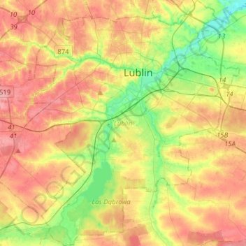
Name: Lublin topographic map, elevation, terrain.
Location: Lublin, Lublin Voivodeship, Poland (51.13981 22.45379 51.29656 22.67354)
Average elevation: 203 m
Minimum elevation: 160 m
Maximum elevation: 243 m
Thank you for supporting this site ❤️
Make a donation
Make a donation
Other topographic maps
Click on a map to view its topography, its elevation and its terrain.
Osada Leśna
Poland > Lublin Voivodeship > Włodawa County > Kołacze > Osada Leśna
Average elevation: 170 m