
Pontével topographic map
Interactive map
Click on the map to display elevation.
About this map
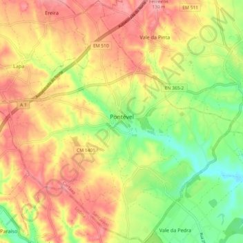
Name: Pontével topographic map, elevation, terrain.
Location: Pontével, Cartaxo, Santarém, 2070-214, Portugal (39.11190 -8.88161 39.18309 -8.79563)
Average elevation: 70 m
Minimum elevation: 3 m
Maximum elevation: 130 m
Other topographic maps
Click on a map to view its topography, its elevation and its terrain.
Vale da Pinta
Vale da Pinta, Cartaxo, Santarém, 2070-559, Portugal
Average elevation: 85 m
Vila Chã de Ourique
Vila Chã de Ourique, Cartaxo, Santarém, 2070-628, Portugal
Average elevation: 45 m