
Make a donation
Guajitos topographic map
Click on the map to display elevation.
Make a donation
About this map
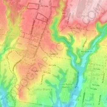
Name: Guajitos topographic map, elevation, terrain.
Average elevation: 1,391 m
Minimum elevation: 1,255 m
Maximum elevation: 1,494 m
Make a donation
Other topographic maps
Click on a map to view its topography, its elevation and its terrain.
Zona 7
Guatemala > Departamento de Guatemala > Ciudad de Guatemala > Colonia Villa de San Juan
Average elevation: 1,524 m
Make a donation
Zona 4
Guatemala > Departamento de Guatemala > Ciudad de Guatemala > Zona 4
Average elevation: 1,503 m
Parque de Jocotenango
Guatemala > Departamento de Guatemala > Ciudad de Guatemala
Average elevation: 1,469 m
Make a donation
Corredor Avenida Reforma
Guatemala > Departamento de Guatemala > Ciudad de Guatemala
Average elevation: 1,504 m
Parque Ecológico Ciudad Nueva
Guatemala > Departamento de Guatemala > Ciudad de Guatemala
Average elevation: 1,453 m
Make a donation
Zona 6
Guatemala > Departamento de Guatemala > Ciudad de Guatemala > Zona 6
Average elevation: 1,457 m
Make a donation
Parque Ecológico Kanajuyú
Guatemala > Departamento de Guatemala > Ciudad de Guatemala > Zona 16
Average elevation: 1,527 m
Parque Erick Barrondo
Guatemala > Departamento de Guatemala > Ciudad de Guatemala > Zona 7
Average elevation: 1,512 m
Make a donation
Make a donation
Centro Cultural Miguel Angel Asturias
Guatemala > Departamento de Guatemala > Ciudad de Guatemala
Average elevation: 1,502 m
Make a donation
Parque Colón
Guatemala > Departamento de Guatemala > Ciudad de Guatemala > Zona 1
Average elevation: 1,487 m
Plaza Vistas de San Isidro
Guatemala > Departamento de Guatemala > Ciudad de Guatemala
Average elevation: 1,635 m
Make a donation
Make a donation
Make a donation
Make a donation
Make a donation
Plaza Berlín
Guatemala > Departamento de Guatemala > Ciudad de Guatemala > Santa Fe
Average elevation: 1,433 m
Make a donation
Make a donation