
Thank you for supporting this site ❤️
Make a donation
Make a donation
Tumusla topographic map
Click on the map to display elevation.
Thank you for supporting this site ❤️
Make a donation
Make a donation
Tumusla
El pueblo está a una altitud de 2620 m s. n. m. a la derecha, margen sur del río Tumusla, que fluye sobre el río San Juan del Oro hasta el río Pilcomayo.
Thank you for supporting this site ❤️
Make a donation
Make a donation
About this map
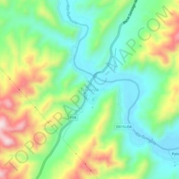
Name: Tumusla topographic map, elevation, terrain.
Average elevation: 2,716 m
Minimum elevation: 2,561 m
Maximum elevation: 2,998 m
Thank you for supporting this site ❤️
Make a donation
Make a donation
Other topographic maps
Click on a map to view its topography, its elevation and its terrain.