
Thank you for supporting this site ❤️
Make a donation
Make a donation
Marion Township topographic map
Click on the map to display elevation.
Thank you for supporting this site ❤️
Make a donation
Make a donation
About this map
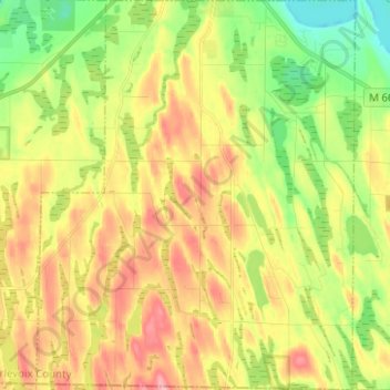
Name: Marion Township topographic map, elevation, terrain.
Location: Marion Township, Charlevoix County, Michigan, United States (45.20550 -85.32404 45.29337 -85.22178)
Average elevation: 220 m
Minimum elevation: 165 m
Maximum elevation: 279 m
Thank you for supporting this site ❤️
Make a donation
Make a donation
Other topographic maps
Click on a map to view its topography, its elevation and its terrain.
Charlevoix South Pier Light
United States > Michigan > Charlevoix County > Charlevoix
Average elevation: 180 m
Boyne Mountain
United States > Michigan > Charlevoix County > Boyne Valley Township
Average elevation: 263 m
Boyne Mountain
United States > Michigan > Charlevoix County > Boyne Valley Township
Average elevation: 263 m
Thank you for supporting this site ❤️
Make a donation
Make a donation