
Make a donation
Lealman topographic map
Click on the map to display elevation.
Make a donation
Lealman
Lealman is located at 27°49′10″N 82°41′4″W / 27.81944°N 82.68444°W / 27.81944; -82.68444 (27.8197, -82.6846). The community is bordered by the city of Pinellas Park to the north, St. Petersburg to the east and south, and by the town of West Lealman to the west. The elevation is 49 feet (15 m) above sea level.
Make a donation
About this map
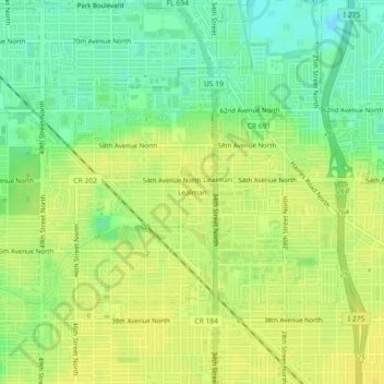
Name: Lealman topographic map, elevation, terrain.
Location: Lealman, Pinellas County, Florida, 33714, United States (27.79979 -82.70226 27.83979 -82.66226)
Average elevation: 13 m
Minimum elevation: -1 m
Maximum elevation: 21 m
Make a donation
Other topographic maps
Click on a map to view its topography, its elevation and its terrain.
Largo
United States > Florida > Pinellas County
In 2010, Largo's total area was 18.6 square miles (48.1 km2), of which 17.6 square miles (45.6 km2) was land and 0.97 square miles (2.5 km2), or 5.22%, was water. As of 2004, there were 651 acres (2.6 km2) of park lands. The city's lowest elevation is sea level. At its highest, the city's elevation is about 69…
Average elevation: 9 m
Make a donation
Make a donation