
Make a donation
Akbou topographic map
Click on the map to display elevation.
Make a donation
Akbou
Akbou is located in the upper Soummam River valley on the eastern flank of the Djurdjura. It is bounded to the north by Ouzellaguen, east by the Soummam River, which separates it from the commune of Amalou, south-east by the Sahel River, locally called "assif abbas", which separates it from the communes of Ait R'Zine, to the south by Tazmalt, to the west by the municipality of Ighram and north-west by the town of Chellata. It is located at an average altitude of 280 m, and the commune covers an area of 52.18 square kilometers, comprising two distinct areas: the urban area and peripheries on the plain such as the villages Lazib and Colonel Amirouche (ex. Riquet).
Make a donation
About this map
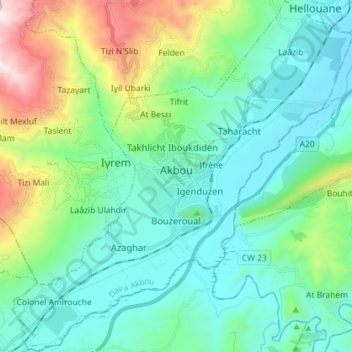
Name: Akbou topographic map, elevation, terrain.
Location: Akbou, Akbou District, Bejaia, 06001, Algeria (36.40019 4.46196 36.51541 4.60146)
Average elevation: 430 m
Minimum elevation: 130 m
Maximum elevation: 1,448 m
Make a donation