
Thank you for supporting this site ❤️
Make a donation
Make a donation
Bukit Goh Lembu topographic map
Click on the map to display elevation.
Thank you for supporting this site ❤️
Make a donation
Make a donation
About this map
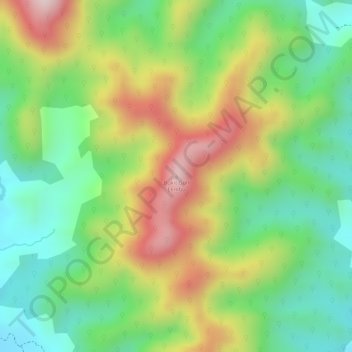
Name: Bukit Goh Lembu topographic map, elevation, terrain.
Location: Bukit Goh Lembu, Padang Terap, Kedah, Malaysia (6.43432 100.70313 6.43442 100.70323)
Average elevation: 227 m
Minimum elevation: 73 m
Maximum elevation: 429 m
Thank you for supporting this site ❤️
Make a donation
Make a donation
Other topographic maps
Click on a map to view its topography, its elevation and its terrain.
Thank you for supporting this site ❤️
Make a donation
Make a donation
Thank you for supporting this site ❤️
Make a donation
Make a donation