
Make a donation
Kansas City topographic map
Click on the map to display elevation.
Make a donation
About this map
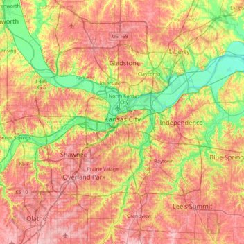
Name: Kansas City topographic map, elevation, terrain.
Location: Kansas City, Jackson County, Missouri, United States (38.82718 -94.76592 39.35666 -94.38552)
Average elevation: 277 m
Minimum elevation: 214 m
Maximum elevation: 339 m
Make a donation
Other topographic maps
Click on a map to view its topography, its elevation and its terrain.
Richard L. Berkley Riverfront Park
United States > Missouri > Jackson County > Kansas City
Average elevation: 242 m
Make a donation
Make a donation
Downtown Kansas City
United States > Missouri > Jackson County > Downtown Kansas City
Average elevation: 271 m
Make a donation
Lee's Summit
United States > Missouri > Jackson County > Lee's Summit
When the surveyors for the Missouri Pacific Railroad came through, the local people and the railroad wanted to name the town in Dr. Lea's honor. He had a farm on the highest point and near the path of the tracks, and his murder had taken place near the site of the proposed depot. So they chose the name of…
Average elevation: 288 m