
Make a donation
Arrowtown topographic map
Click on the map to display elevation.
Make a donation
About this map
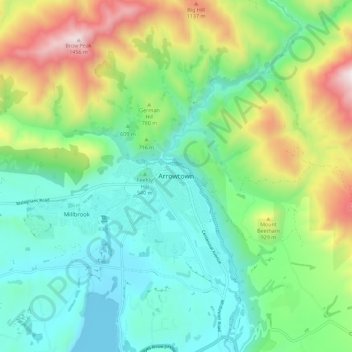
Name: Arrowtown topographic map, elevation, terrain.
Location: Arrowtown, Queenstown-Lakes District, 9302, New Zealand (-44.98056 168.79508 -44.90056 168.87508)
Average elevation: 671 m
Minimum elevation: 328 m
Maximum elevation: 1,470 m
Queenstown-Lakes District trails, hiking, mountain biking, running and outdoor activities
Make a donation
Other topographic maps
Click on a map to view its topography, its elevation and its terrain.
Pisa Range
New Zealand > Queenstown-Lakes District > Cromwell Community
Elevation ranges from approximately 450 to 1,963 m (1,476 to 6,440 ft) at the highest point. The aerial extent of the range is defined by the Clutha River / Lake Dunstan to the north and east, while the Cardrona River and Kawarau River lie on the western and southern boundaries, respectively.
Average elevation: 1,253 m
Make a donation
The Remarkables
New Zealand > Queenstown-Lakes District
The area contains a number of beautiful features, such as Lake Alta, a small lake nestled within a natural amphitheatre at the head of a glacial valley (a ‘cirque’) and below the towering Double Cone peaks. There are a number of high altitude walks in the Remarkables Conservation Area including Lake Alta…
Average elevation: 1,200 m
Make a donation