
Thank you for supporting this site ❤️
Make a donation
Make a donation
Waimate topographic map
Click on the map to display elevation.
Thank you for supporting this site ❤️
Make a donation
Make a donation
About this map
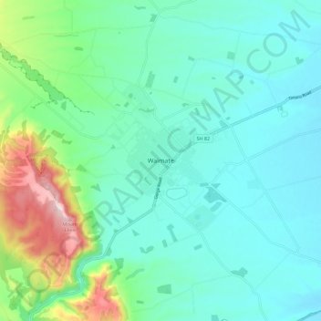
Name: Waimate topographic map, elevation, terrain.
Location: Waimate, Waimate District, Canterbury, 7924, New Zealand (-44.77388 171.00234 -44.69388 171.08234)
Average elevation: 100 m
Minimum elevation: 17 m
Maximum elevation: 408 m
Waimate District trails, hiking, mountain biking, running and outdoor activities
Thank you for supporting this site ❤️
Make a donation
Make a donation
Other topographic maps
Click on a map to view its topography, its elevation and its terrain.