
Make a donation
Burnt Pine topographic map
Click on the map to display elevation.
Make a donation
About this map
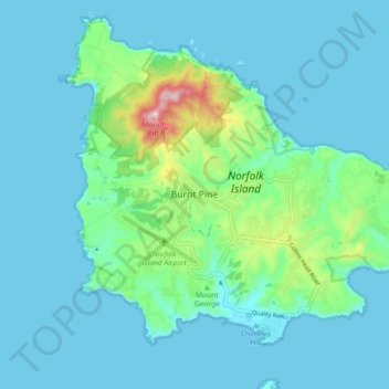
Name: Burnt Pine topographic map, elevation, terrain.
Location: Burnt Pine, Norfolk Island, 2899, Australia (-29.07180 167.90658 -28.99180 167.98658)
Average elevation: 46 m
Minimum elevation: 0 m
Maximum elevation: 312 m
Make a donation
Other topographic maps
Click on a map to view its topography, its elevation and its terrain.
Make a donation
Lake Eyre (North)
The −15 m (−49 ft) altitude usually attributed to Kati Thanda–Lake Eyre refers to the deepest parts of the lake floor, in Belt Bay and the Madigan Gulf. The shoreline lies at −9 m (−30 ft). The lake is the area of maximum deposition of sediment in the Lake Eyre Basin.
Average elevation: 2 m
Make a donation
Launceston
Launceston is at 41°26′31″S 147°8′42″E / 41.44194°S 147.14500°E / -41.44194; 147.14500 in the Tamar Valley, Northern Tasmania. The valley was formed by volcanic and glacial forces over 10 million years ago. The city is about 45 kilometres (28 mi) south of the Bass Strait, with its closest…
Average elevation: 194 m
Make a donation
Cocos (Keeling) Islands
The Cocos (Keeling) Islands consist of two flat, low-lying coral atolls with an area of 14.2 square kilometres (5.5 sq mi), 26 kilometres (16 mi) of coastline, a highest elevation of 5 metres (16 ft) and thickly covered with coconut palms and other vegetation. The climate is pleasant, moderated by the…
Average elevation: 0 m
Mount Barker
The peak of Mount Barker lies 3.5 kilometres (2.2 mi) southwest of the town centre, and reaches an elevation of 404 metres (1,325 ft) above sea level. A sealed road leads to the base of a radio and television tower on the summit of the hill. The tower was constructed to a height of 168 metres (551 ft) in 1966,…
Average elevation: 211 m
Make a donation
Make a donation
Make a donation
Make a donation
Western Australia
Because the only mountain-building since then has been of the Stirling Range with the rifting from Antarctica, the land is extremely eroded and ancient, with no part of the state above 1,249 metres (4,098 ft) AHD (at Mount Meharry in the Hamersley Range of the Pilbara region). Most of the state is a low…
Average elevation: 194 m
Make a donation
Make a donation
Make a donation
Make a donation
Make a donation
Tasmania
The most mountainous region is the Central Highlands area, which covers most of the central western parts of the state. The Midlands located in the central east, is fairly flat, and is predominantly used for agriculture, although farming activity is scattered throughout the state. Tasmania's tallest mountain…
Average elevation: 6 m
Make a donation
Make a donation
Make a donation
Make a donation
Edmonton
Australia > Queensland > Edmonton
The average elevation of Edmonton, Cairns is 16.8 metres (55.1 feet) above sea level.
Average elevation: 96 m
Make a donation
Make a donation
Make a donation
Make a donation
Make a donation
Make a donation
Make a donation
Make a donation
Make a donation