
Make a donation
Sky Londa topographic map
Click on the map to display elevation.
Make a donation
Sky Londa
Atop the coastal range west of Woodside, the community's official elevation is 1,520 feet (463 m) above mean sea level (AMSL).
Make a donation
About this map
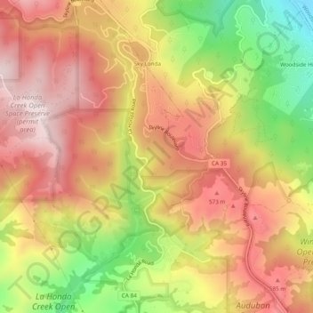
Name: Sky Londa topographic map, elevation, terrain.
Average elevation: 438 m
Minimum elevation: 112 m
Maximum elevation: 672 m
Make a donation
Other topographic maps
Click on a map to view its topography, its elevation and its terrain.
Upper Crystal Springs Reservoir
United States > California > San Mateo County
Average elevation: 120 m
Make a donation
Make a donation
Highlands
United States > California > San Mateo County > San Mateo Highlands
Average elevation: 129 m
Make a donation
Burlingame
United States > California > San Mateo County > Burlingame > Burlingame
Average elevation: 56 m
San Carlos
United States > California > San Mateo County > San Carlos > San Carlos
Average elevation: 47 m
Pillar Point Harbor
United States > California > San Mateo County > El Granada
Average elevation: 13 m
Make a donation
Half Moon Bay
United States > California > San Mateo County > Half Moon Bay > Half Moon Bay
Average elevation: 73 m
Coyote Point Recreation Area
United States > California > San Mateo County > San Mateo
Average elevation: 1 m
Westborough
United States > California > San Mateo County > South San Francisco
Average elevation: 120 m
Make a donation