
Thank you for supporting this site ❤️
Make a donation
Make a donation
Jimboomba topographic map
Click on the map to display elevation.
Thank you for supporting this site ❤️
Make a donation
Make a donation
About this map
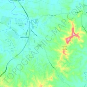
Name: Jimboomba topographic map, elevation, terrain.
Location: Jimboomba, Logan City, Queensland, Australia (-27.88909 152.99926 -27.78882 153.08657)
Average elevation: 59 m
Minimum elevation: 10 m
Maximum elevation: 239 m
Thank you for supporting this site ❤️
Make a donation
Make a donation
Other topographic maps
Click on a map to view its topography, its elevation and its terrain.