
Thank you for supporting this site ❤️
Make a donation
Make a donation
Moreno Valley topographic map
Click on the map to display elevation.
Thank you for supporting this site ❤️
Make a donation
Make a donation
About this map
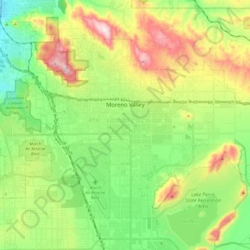
Name: Moreno Valley topographic map, elevation, terrain.
Location: Moreno Valley, Riverside County, California, United States (33.85868 -117.29652 33.98510 -117.08820)
Average elevation: 527 m
Minimum elevation: 291 m
Maximum elevation: 941 m
Thank you for supporting this site ❤️
Make a donation
Make a donation
Other topographic maps
Click on a map to view its topography, its elevation and its terrain.
Temescal Creek
United States > California > Riverside County > Temescal Valley
Average elevation: 317 m