
Bornholms Regionskommune topographic map
Interactive map
Click on the map to display elevation.
About this map
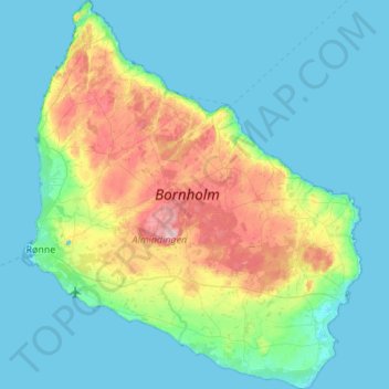
Name: Bornholms Regionskommune topographic map, elevation, terrain.
Location: Bornholms Regionskommune, Hauptstadtregion, Dänemark (54.98724 14.67920 55.29912 15.15735)
Average elevation: 33 m
Minimum elevation: -1 m
Maximum elevation: 162 m
Other topographic maps
Click on a map to view its topography, its elevation and its terrain.
Rønne
Rønne, Bornholms Regionskommune, Hauptstadtregion, 3700, Dänemark
Average elevation: 16 m
Døndalen
Dänemark > Hauptstadtregion > Rø
Døndalen, Rø, Bornholms Regionskommune, Hauptstadtregion, Dänemark
Average elevation: 56 m
Olsker
Olsker, Bornholms Regionskommune, Hauptstadtregion, 3770, Dänemark
Average elevation: 84 m
Vestermarie
Vestermarie, Bornholms Regionskommune, Hauptstadtregion, Dänemark
Average elevation: 80 m
Albertslund Kommune
Albertslund Kommune, Hauptstadtregion, 2620, Dänemark
Average elevation: 18 m
Hirschholm
Hirschholm, Hørsholm Kommune, Hauptstadtregion, 2970, Dänemark
Average elevation: 23 m
Kopenhagen
Kopenhagen, Hauptstadtregion, 1357, Dänemark
Average elevation: 9 m
Hornbæk
Hornbæk, Helsingør Kommune, Hauptstadtregion, 3100, Dänemark
Average elevation: 10 m
Frederiksberg
Frederiksberg, Frederiksberg Kommune, Hauptstadtregion, 1861, Dänemark
Average elevation: 11 m
Hilleröd
Hilleröd, Hillerød Kommune, Hauptstadtregion, 3400, Dänemark
Average elevation: 36 m
Lynge
Lynge, Allerød Kommune, Hauptstadtregion, 3540, Dänemark
Average elevation: 42 m
Jungen
Dänemark > Hauptstadtregion > Store Lyngby
Jungen, Store Lyngby, Hillerød Kommune, Hauptstadtregion, 3320, Dänemark
Average elevation: 9 m
Nydam
Nydam, Bagsværd, Gladsaxe Kommune, Hauptstadtregion, Dänemark
Average elevation: 31 m
Gladsaxe Kommune
Gladsaxe Kommune, Hauptstadtregion, Dänemark
Average elevation: 30 m
Helsingör
Helsingör, Helsingør Kommune, Hauptstadtregion, 3000, Dänemark
Average elevation: 11 m
Lyngby-Taarbæk Kommune
Lyngby-Taarbæk Kommune, Hauptstadtregion, Dänemark
Average elevation: 28 m
Gentofte Kommune
Gentofte Kommune, Hauptstadtregion, Dänemark
Average elevation: 20 m
Frederiksberg Kommune
Frederiksberg Kommune, Hauptstadtregion, Dänemark
Average elevation: 15 m
Søgård
Dänemark > Hauptstadtregion > Søgård
Søgård, Egedal Kommune, Hauptstadtregion, 3650, Dänemark
Average elevation: 25 m
Gribskov Kommune
Gribskov Kommune, Hauptstadtregion, Dänemark
Average elevation: 14 m