
Laruns topographic map
Interactive map
Click on the map to display elevation.
About this map
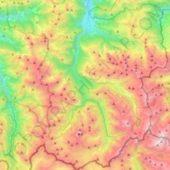
Name: Laruns topographic map, elevation, terrain.
Average elevation: 1,664 m
Minimum elevation: 465 m
Maximum elevation: 3,105 m
Son altitude varie de 500 m mètres à 2 974 m.
Other topographic maps
Click on a map to view its topography, its elevation and its terrain.
Lac Gentau
France > Nouvelle-Aquitaine > Laruns
Lac Gentau, Chemin du Refuge d'Ayous, Laruns, Oloron-Sainte-Marie, Pyrénées-Atlantiques, Nouvelle-Aquitaine, France métropolitaine, 64440, France
Average elevation: 1,986 m