
Make a donation
Taiyuan topographic map
Click on the map to display elevation.
Make a donation
Taiyuan
Taiyuan experiences a cold semi-arid climate (Köppen climate classification BSk). Taiyuan has a temperate monsoon climate. Spring is dry, with occasional dust storms, followed by early summer heat waves. Summer tends to be warm to hot with most of the year's rainfall concentrated in July and August. Winter is long and cold, but dry and sunny. Because of the aridity, there tends to be considerable diurnal variation in temperature, except during the summer. The weather is much cooler than comparable-latitude cities, such as Shijiazhuang, due to the moderately high altitude. The monthly 24-hour average temperature range from −5.0 °C (23.0 °F) in January to 24.0 °C (75.2 °F) in July, while the annual mean is 10.42 °C (50.8 °F). With monthly percent possible sunshine ranging from 51 percent in July to 61 percent in May, there are 2,502 hours of sunshine annually.
Make a donation
About this map
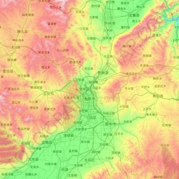
Name: Taiyuan topographic map, elevation, terrain.
Location: Taiyuan, Shanxi, China (37.44142 111.50892 38.42085 113.14779)
Average elevation: 1,195 m
Minimum elevation: 550 m
Maximum elevation: 2,376 m
Make a donation
Other topographic maps
Click on a map to view its topography, its elevation and its terrain.