
Trébosc topographic map
Interactive map
Click on the map to display elevation.
About this map
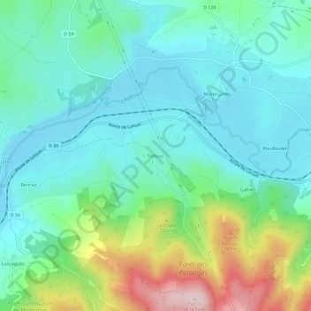
Name: Trébosc topographic map, elevation, terrain.
Average elevation: 634 m
Minimum elevation: 551 m
Maximum elevation: 873 m
Other topographic maps
Click on a map to view its topography, its elevation and its terrain.
Gages le Haut
France > Occitanie > Aveyron > Montrozier > Gages-Montrozier
Gages le Haut, Gages-Montrozier, Montrozier, Rodez, Aveyron, Occitanie, France métropolitaine, 12630, France
Average elevation: 596 m
Gages-Montrozier
France > Occitanie > Aveyron > Montrozier
Gages-Montrozier, Montrozier, Rodez, Aveyron, Occitanie, France métropolitaine, 12630, France
Average elevation: 613 m