
Thank you for supporting this site ❤️
Make a donation
Make a donation
Palestine topographic map
Click on the map to display elevation.
Thank you for supporting this site ❤️
Make a donation
Make a donation
About this map
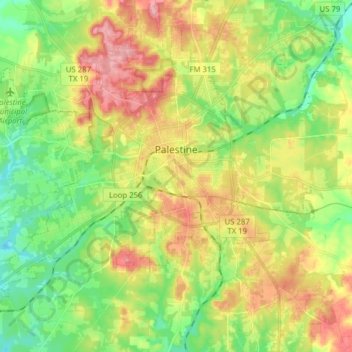
Name: Palestine topographic map, elevation, terrain.
Location: Palestine, Anderson County, Texas, USA (31.69527 -95.72426 31.80843 -95.56776)
Average elevation: 136 m
Minimum elevation: 85 m
Maximum elevation: 204 m
Thank you for supporting this site ❤️
Make a donation
Make a donation