
Thank you for supporting this site ❤️
Make a donation
Make a donation
Worthing topographic map
Click on the map to display elevation.
Thank you for supporting this site ❤️
Make a donation
Make a donation
About this map
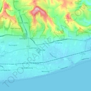
Name: Worthing topographic map, elevation, terrain.
Location: Worthing, West Sussex, England, United Kingdom (50.80174 -0.44656 50.86326 -0.33026)
Average elevation: 35 m
Minimum elevation: -2 m
Maximum elevation: 183 m
Thank you for supporting this site ❤️
Make a donation
Make a donation
Other topographic maps
Click on a map to view its topography, its elevation and its terrain.
Highbrook
United Kingdom > England > West Sussex > Mid Sussex District > West Hoathly
Average elevation: 93 m