
Village of Mamaroneck topographic map
Interactive map
Click on the map to display elevation.
About this map
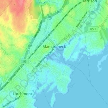
Name: Village of Mamaroneck topographic map, elevation, terrain.
Average elevation: 15 m
Minimum elevation: -3 m
Maximum elevation: 65 m
Other areas of the town include Heathcote Hill, overlooking the harbor, Harbor Heights (the heights) to the northeast, Old Rye Neck (settled in the 1880s), Rye Neck (settled in the 1920s and 1930s), Orienta, and Washingtonville, better known as "The Flats", due to the flat, low-lying topography of the area.
Other topographic maps
Click on a map to view its topography, its elevation and its terrain.
City of Rye
United States > New York > Westchester County
City of Rye, Westchester County, New York, United States
Average elevation: 9 m
City of White Plains
United States > New York > Westchester County
City of White Plains, Westchester County, New York, United States
Average elevation: 83 m
City of Yonkers
United States > New York > Westchester County
City of Yonkers, Westchester County, New York, United States
Average elevation: 58 m
Village of Scarsdale
United States > New York > Westchester County
Village of Scarsdale, Westchester County, New York, 10583, United States
Average elevation: 76 m
Village of Tuckahoe
United States > New York > Westchester County > Town of Eastchester
Village of Tuckahoe, Town of Eastchester, Westchester County, New York, United States
Average elevation: 57 m
Village of Hastings-on-Hudson
United States > New York > Westchester County
Village of Hastings-on-Hudson, Town of Greenburgh, Westchester County, New York, 10706, United States
Average elevation: 49 m
Mariandale
United States > New York > Westchester County > Village of Ossining
Mariandale, Village of Ossining, Town of Ossining, Westchester County, New York, 10562, United States
Average elevation: 53 m
Town of North Castle
United States > New York > Westchester County
Town of North Castle, Westchester County, New York, 10504, United States
Average elevation: 134 m
Jefferson Valley-Yorktown
United States > New York > Westchester County
Jefferson Valley-Yorktown, Westchester County, New York, 10535, United States
Average elevation: 164 m
Crompond
United States > New York > Westchester County > Town of Cortlandt
Crompond, Town of Cortlandt, Westchester County, New York, 10517, United States
Average elevation: 131 m
City of Peekskill
United States > New York > Westchester County
City of Peekskill, Westchester County, New York, 10566, United States
Average elevation: 67 m
Roe Park
United States > New York > Westchester County > Town of Cortlandt
Roe Park, Town of Cortlandt, Westchester County, New York, 10567, United States
Average elevation: 106 m
Village of Croton-on-Hudson
United States > New York > Westchester County > Town of Cortlandt
Village of Croton-on-Hudson, Town of Cortlandt, Westchester County, New York, 10520, United States
Average elevation: 42 m
Pleasantside
United States > New York > Westchester County > Town of Cortlandt
Pleasantside, Town of Cortlandt, Westchester County, New York, 10567, United States
Average elevation: 108 m
Village of Ossining
United States > New York > Westchester County > Town of Ossining
Village of Ossining, Town of Ossining, Westchester County, New York, 10562, United States
Average elevation: 61 m
Chappaqua
United States > New York > Westchester County
Chappaqua, Town of New Castle, Westchester County, New York, United States
Average elevation: 149 m
Yorktown Heights
United States > New York > Westchester County > Town of Yorktown
Yorktown Heights, Town of Yorktown, Westchester County, New York, United States
Average elevation: 159 m
Salem Center
United States > New York > Westchester County > Town of North Salem
Salem Center, Town of North Salem, Westchester County, New York, 10560, United States
Average elevation: 147 m
Armonk
United States > New York > Westchester County
Armonk, Town of North Castle, Westchester County, New York, 10504, United States
Average elevation: 156 m
Bonnie Crest
United States > New York > Westchester County > City of New Rochelle
Bonnie Crest, City of New Rochelle, Westchester County, New York, 10804, United States
Average elevation: 58 m
Crugers
United States > New York > Westchester County > Town of Cortlandt
Crugers, Town of Cortlandt, Westchester County, New York, 10521, United States
Average elevation: 23 m
Thornwood
United States > New York > Westchester County > Town of Mount Pleasant
Thornwood, Town of Mount Pleasant, Westchester County, New York, 10594, United States
Average elevation: 121 m
Vernon Park
United States > New York > Westchester County > City of Mount Vernon
Vernon Park, City of Mount Vernon, Westchester County, New York, 10553, United States
Average elevation: 31 m
Village of Dobbs Ferry
United States > New York > Westchester County
Village of Dobbs Ferry, Town of Greenburgh, Westchester County, New York, United States
Average elevation: 54 m
Lake Mohansic
United States > New York > Westchester County > Town of Yorktown
Lake Mohansic, Town of Yorktown, Westchester County, New York, United States
Average elevation: 159 m
Van Cortlandt Park
United States > New York > Westchester County > New York
Van Cortlandt Park, New York, Westchester County, New York, United States
Average elevation: 42 m
Town of Mamaroneck
United States > New York > Westchester County
Town of Mamaroneck, Westchester County, New York, 10538, United States
Average elevation: 18 m
Goldens Bridge
United States > New York > Westchester County > Town of Lewisboro
Goldens Bridge, Town of Lewisboro, Westchester County, New York, United States
Average elevation: 94 m
Hawthorne
United States > New York > Westchester County > Town of Mount Pleasant
Hawthorne, Town of Mount Pleasant, Westchester County, New York, 10532, United States
Average elevation: 114 m
Cecil Park
United States > New York > Westchester County > City of Yonkers
Cecil Park, City of Yonkers, Westchester County, New York, 10707, United States
Average elevation: 70 m
Park Hill
United States > New York > Westchester County > City of Yonkers
Park Hill, City of Yonkers, Westchester County, New York, 10705, United States
Average elevation: 43 m
Colonial Heights
United States > New York > Westchester County > City of Yonkers
Colonial Heights, City of Yonkers, Westchester County, New York, 10710, United States
Average elevation: 60 m
Grey Oaks
United States > New York > Westchester County > City of Yonkers
Grey Oaks, City of Yonkers, Westchester County, New York, 10703, United States
Average elevation: 60 m
West Harrison Village Green
United States > New York > Westchester County > Town/Village of Harrison > East White Plains
West Harrison Village Green, East White Plains, Town/Village of Harrison, Westchester County, New York, United States
Average elevation: 79 m
Town of New Castle
United States > New York > Westchester County
Town of New Castle, Westchester County, New York, United States
Average elevation: 133 m
Tompkins Corners
United States > New York > Westchester County
Tompkins Corners, Town of New Castle, Westchester County, New York, 10546, United States
Average elevation: 142 m
Lowerre
United States > New York > Westchester County > City of Yonkers
Lowerre, City of Yonkers, Westchester County, New York, 10705, United States
Average elevation: 34 m
Crestwood Gardens
United States > New York > Westchester County > City of Yonkers
Crestwood Gardens, City of Yonkers, Westchester County, New York, 10707, United States
Average elevation: 65 m
Sedge Island
United States > New York > Westchester County > City of New Rochelle
Sedge Island, City of New Rochelle, Westchester County, New York, 10805, United States
Average elevation: 47 m
South Salem
United States > New York > Westchester County > Town of Lewisboro
South Salem, Town of Lewisboro, Westchester County, New York, 10590, United States
Average elevation: 176 m
Village of Briarcliff Manor
United States > New York > Westchester County
Village of Briarcliff Manor, Town of Ossining, Westchester County, New York, 10510, United States
Average elevation: 114 m
Milton
United States > New York > Westchester County > City of Rye
Milton, City of Rye, Westchester County, New York, 10587, United States
Average elevation: 9 m
Shenorock
United States > New York > Westchester County > Town of Somers
Shenorock, Town of Somers, Westchester County, New York, United States
Average elevation: 149 m
Town of Lewisboro
United States > New York > Westchester County
Town of Lewisboro, Westchester County, New York, United States
Average elevation: 162 m
Town of Mount Pleasant
United States > New York > Westchester County
Town of Mount Pleasant, Westchester County, New York, United States
Average elevation: 116 m
Pine Island
United States > New York > Westchester County > City of Rye
Pine Island, City of Rye, Westchester County, New York, 10587, United States
Average elevation: 50 m
Jefferson Valley
United States > New York > Westchester County > Jefferson Valley-Yorktown
Jefferson Valley, Jefferson Valley-Yorktown, Westchester County, New York, 10535, United States
Average elevation: 178 m
Gunther Park
United States > New York > Westchester County > City of Yonkers
Gunther Park, City of Yonkers, Westchester County, New York, 10704, United States
Average elevation: 56 m
Chauncey
United States > New York > Westchester County > Village of Dobbs Ferry
Chauncey, Village of Dobbs Ferry, Town of Greenburgh, Westchester County, New York, 10572, United States
Average elevation: 76 m
Town of Pound Ridge
United States > New York > Westchester County
Town of Pound Ridge, Westchester County, New York, 10576, United States
Average elevation: 156 m