
Thank you for supporting this site ❤️
Make a donation
Make a donation
El Coyotepe topographic map
Click on the map to display elevation.
Thank you for supporting this site ❤️
Make a donation
Make a donation
About this map
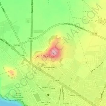
Name: El Coyotepe topographic map, elevation, terrain.
Location: El Coyotepe, Masaya, 41000, Nicaragua (11.99585 -86.09856 11.99595 -86.09846)
Average elevation: 233 m
Minimum elevation: 126 m
Maximum elevation: 338 m
Thank you for supporting this site ❤️
Make a donation
Make a donation
Other topographic maps
Click on a map to view its topography, its elevation and its terrain.