
Make a donation
Kalayaan topographic map
Click on the map to display elevation.
Make a donation
Kalayaan
Kalayaan is roughly rectangular in shape, with a hilly terrain on most of its eastern side, while relatively flat on its western side. Its highest elevations are from 400 to 418 metres. These are found in Sitio Santo Angel, Malaking Pulo, and Cabuhayan in Barangay San Juan, and Sitio Lamao in Barangay San Antonio. Approximately three fourths of the total land area are with terrain 300 metres above sea level. Its lowest points are from 5 to 20 metres along the western sections of Barangays San Juan and Longos towards Laguna de Bay.
Make a donation
About this map
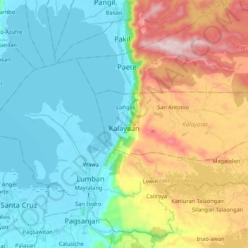
Name: Kalayaan topographic map, elevation, terrain.
Location: Kalayaan, Laguna, Calabarzon, 4015, Philippines (14.30808 121.46175 14.35190 121.61449)
Average elevation: 159 m
Minimum elevation: -3 m
Maximum elevation: 526 m
Make a donation
Other topographic maps
Click on a map to view its topography, its elevation and its terrain.
Mount Banahaw and San Cristobal Protected Landscape
Philippines > Laguna > Liliw
Average elevation: 592 m
Make a donation
Make a donation
Make a donation
Make a donation
Make a donation