Romeira topographic map
Interactive map
Click on the map to display elevation.
About this map
![Romeira topographic map, elevation, terrain](/pub/maps/node/q7nx/lf24rbgp/thumbnail.jpg)
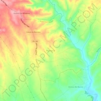
Name: Romeira topographic map, elevation, terrain.
Location: Romeira, Santarém, 2005-096, Portugal (39.28972 -8.74475 39.32972 -8.70475)
Average elevation: 84 m
Minimum elevation: 18 m
Maximum elevation: 155 m
Other topographic maps
Click on a map to view its topography, its elevation and its terrain.
![Aldeia da Ribeira topographic map, elevation, terrain](/pub/maps/node/bt5k/x5x8xf14/icon.jpg)
Aldeia da Ribeira
Portugal > Santarém > Santarém > Alcanede
Aldeia da Ribeira, Alcanede, Santarém, 2040-172, Portugal
Average elevation: 92 m
![Póvoa da Isenta topographic map, elevation, terrain](/pub/maps/relation/4lgt/w6pb4s/icon.jpg)
Póvoa da Isenta
Portugal > Santarém > Santarém
Póvoa da Isenta, Santarém, Portugal
Average elevation: 49 m
![Arneiro das Milhariças topographic map, elevation, terrain](/pub/maps/relation/bcnx/9fnw18/icon.jpg)
Arneiro das Milhariças
Portugal > Santarém > Santarém
Arneiro das Milhariças, Santarém, Portugal
Average elevation: 99 m
![Casével e Vaqueiros topographic map, elevation, terrain](/pub/maps/relation/wz5k/p2xm3q/icon.jpg)
Casével e Vaqueiros
Portugal > Santarém > Santarém
Casével e Vaqueiros, Santarém, Portugal
Average elevation: 66 m
![Póvoa de Santarém topographic map, elevation, terrain](/pub/maps/node/8wrr/7fvwtrtf/icon.jpg)
Póvoa de Santarém
Portugal > Santarém > Santarém
Póvoa de Santarém, Santarém, 2000, Portugal
Average elevation: 61 m
![Amiais de Baixo topographic map, elevation, terrain](/pub/maps/relation/f9b3/bk4jtf/icon.jpg)
Amiais de Baixo
Portugal > Santarém > Santarém
Amiais de Baixo, Santarém, 2835-333, Portugal
Average elevation: 132 m
![Vale de Santarém topographic map, elevation, terrain](/pub/maps/relation/95t6/632knh/icon.jpg)
Vale de Santarém
Portugal > Santarém > Santarém
Vale de Santarém, Santarém, 2005-039, Portugal
Average elevation: 35 m