Geolocate

Isanti topographic map

Click on the map to display elevation.

About this map

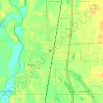
Name: Isanti topographic map, elevation, terrain.

Location: Isanti, Isanti County, Minnesota, United States (45.46767 -93.27075 45.51173 -93.20914)

Average elevation: 285 m

Minimum elevation: 271 m

Maximum elevation: 295 m

Other topographic maps

Click on a map to view its topography, its elevation and its terrain.

Stanchfield

United States > Minnesota > Isanti County

Average elevation: 287 m

Crown

United States > Minnesota > Isanti County

Average elevation: 295 m

Day

United States > Minnesota > Isanti County

Average elevation: 302 m

Grandy

United States > Minnesota > Isanti County

Average elevation: 285 m

Wyanett

United States > Minnesota > Isanti County

Average elevation: 293 m

Andree

United States > Minnesota > Isanti County

Average elevation: 291 m

Athens

United States > Minnesota > Isanti County

Average elevation: 284 m

Blomford

United States > Minnesota > Isanti County

Average elevation: 290 m

Bradford

United States > Minnesota > Isanti County

Average elevation: 287 m

Carmody

United States > Minnesota > Isanti County

Average elevation: 299 m

Dalbo

United States > Minnesota > Isanti County

Average elevation: 296 m

Edgewood

United States > Minnesota > Isanti County

Average elevation: 289 m

Elm Park

United States > Minnesota > Isanti County

Average elevation: 290 m

Oxlip

United States > Minnesota > Isanti County

Average elevation: 288 m

Pine Brook

United States > Minnesota > Isanti County

Average elevation: 291 m

Spencer Brook

United States > Minnesota > Isanti County

Average elevation: 289 m

Spring Lake

United States > Minnesota > Isanti County

Average elevation: 286 m

Springvale

United States > Minnesota > Isanti County

Average elevation: 288 m

Stanley

United States > Minnesota > Isanti County

Average elevation: 293 m

Walbo

United States > Minnesota > Isanti County

Average elevation: 286 m

Weber

United States > Minnesota > Isanti County

Average elevation: 282 m

West Point

United States > Minnesota > Isanti County

Average elevation: 287 m

Bodum

United States > Minnesota > Isanti County

Average elevation: 294 m