
Planevialle topographic map
Interactive map
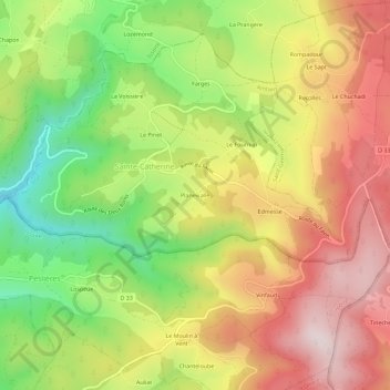
Click on the map to display elevation.
About this map
Name: Planevialle topographic map, elevation, terrain.
Average elevation: 903 m
Minimum elevation: 637 m
Maximum elevation: 1,150 m
Other topographic maps
Click on a map to view its topography, its elevation and its terrain.
Le Pinet
France > Auvergne-Rhône-Alpes > Puy-de-Dôme > Sainte-Catherine
Le Pinet, Sainte-Catherine, Ambert, Puy-de-Dôme, Auvergne-Rhône-Alpes, France métropolitaine, 63580, France
Average elevation: 861 m