
Thank you for supporting this site ❤️
Make a donation
Make a donation
Glan-yr-afon topographic map
Click on the map to display elevation.
Thank you for supporting this site ❤️
Make a donation
Make a donation
About this map
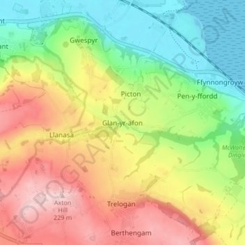
Name: Glan-yr-afon topographic map, elevation, terrain.
Location: Glan-yr-afon, Flintshire, Wales, CH8 9BJ, United Kingdom (53.30431 -3.34708 53.34431 -3.30708)
Average elevation: 104 m
Minimum elevation: -1 m
Maximum elevation: 229 m
Thank you for supporting this site ❤️
Make a donation
Make a donation
Other topographic maps
Click on a map to view its topography, its elevation and its terrain.