
Thank you for supporting this site ❤️
Make a donation
Make a donation
Lebução topographic map
Click on the map to display elevation.
Thank you for supporting this site ❤️
Make a donation
Make a donation
About this map
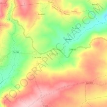
Name: Lebução topographic map, elevation, terrain.
Location: Lebução, Valpaços, Vila Real, 5430-167, Portugal (41.73753 -7.27954 41.77753 -7.23954)
Average elevation: 686 m
Minimum elevation: 566 m
Maximum elevation: 783 m
Thank you for supporting this site ❤️
Make a donation
Make a donation
Other topographic maps
Click on a map to view its topography, its elevation and its terrain.
Thank you for supporting this site ❤️
Make a donation
Make a donation