
Thank you for supporting this site ❤️
Make a donation
Make a donation
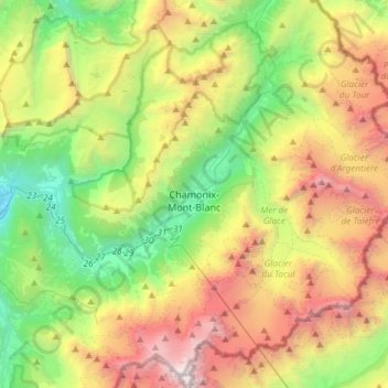
Chamonix-Mont-Blanc topographic map
Click on the map to display elevation.
Thank you for supporting this site ❤️
Make a donation
Make a donation
Chamonix-Mont-Blanc
Due to its elevation, Chamonix has a humid continental climate (Dfb, according to the Köppen climate classification), with an average annual precipitation of 1,280 mm (50 in). Summers are mild and winters are cold and snowy.
Thank you for supporting this site ❤️
Make a donation
Make a donation
About this map
Name: Chamonix-Mont-Blanc topographic map, elevation, terrain.
Average elevation: 2,209 m
Minimum elevation: 612 m
Maximum elevation: 4,798 m
Thank you for supporting this site ❤️
Make a donation
Make a donation
Other topographic maps
Click on a map to view its topography, its elevation and its terrain.