
Thank you for supporting this site ❤️
Make a donation
Make a donation
Alloy topographic map
Click on the map to display elevation.
Thank you for supporting this site ❤️
Make a donation
Make a donation
About this map
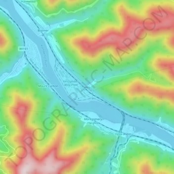
Name: Alloy topographic map, elevation, terrain.
Location: Alloy, Fayette County, West Virginia, 25189, United States (38.11761 -81.29428 38.15761 -81.25428)
Average elevation: 351 m
Minimum elevation: 183 m
Maximum elevation: 655 m
Thank you for supporting this site ❤️
Make a donation
Make a donation
Other topographic maps
Click on a map to view its topography, its elevation and its terrain.