
San Buenaventura (Ventura) topographic map
Interactive map
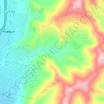
Click on the map to display elevation.
San Buenaventura (Ventura) topographic map, elevation, terrain
About this map
Name: San Buenaventura (Ventura) topographic map, elevation, terrain.
Average elevation: 158 m
Minimum elevation: 23 m
Maximum elevation: 353 m
Other topographic maps
Click on a map to view its topography, its elevation and its terrain.
Camarillo
United States > California > Ventura County
In the mid-1950s, the Ventura Freeway was completed from Los Angeles to points north, making it an easy one-hour trip to Camarillo. The Old Town was bisect by the Ventura Freeway. On the southern side of the freeway contains a strip of businesses, churches, schools, and parks. The freeway was originally…
Average elevation: 90 m
Ojai
United States > California > Ventura County
The Ojai Valley lies within the Topatopa Mountains on the north and south and is actively shaped by a web of earthquake faults. The Sisar fault in the valley was the epicenter of a magnitude 5.1 earthquake on August 20, 2023. The Santa Ynez Mountains lie to the north, while Sulphur Mountain and the lower Black…
Average elevation: 289 m
Simi Valley
United States > California > Ventura County
Simi Valley is a city located in the very southeast corner of Ventura County, bordering the San Fernando Valley in Los Angeles County, and is a part of the Greater Los Angeles Area. The City of Simi Valley basically consists of the eponymous valley itself. City of Simi Valley borders the Santa Susana Mountains…
Average elevation: 405 m