
Make a donation
Trikala Regional Unit topographic map
Click on the map to display elevation.
Make a donation
About this map
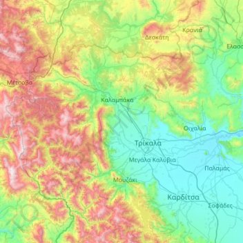
Name: Trikala Regional Unit topographic map, elevation, terrain.
Average elevation: 709 m
Minimum elevation: 83 m
Maximum elevation: 2,380 m
Make a donation
Other topographic maps
Click on a map to view its topography, its elevation and its terrain.
Meteora
Greece > Thessaly > Trikala Regional Unit > Kastraki
The Monastery of Rousanou is believed to have been constructed, like many of the other monasteries, in the 14th century. The cathedral is believed to have been built in the 16th century and later decorated in 1540. The name Rousanou is believed to come from the first group of monks who settled on the rock from…
Average elevation: 429 m
Neo Perivoli
Greece > Thessaly > Larisa Regional Unit > Municipal Unit of Kileler
Average elevation: 146 m
Make a donation
Περτούλι
Greece > Thessaly > Trikala Regional Unit
Pertouli is a small mountain village within the province of Trikala in Greece and is situated at an altitude of 1,150 metres on the central part of the Pindos mountain range.
Average elevation: 1,358 m
Περτούλι
Greece > Thessaly > Trikala Regional Unit
Pertouli is a small mountain village within the province of Trikala in Greece and is situated at an altitude of 1,150 metres on the central part of the Pindos mountain range.
Average elevation: 1,358 m
Make a donation
Συκή
Greece > Thessaly > Regional Unit of Magnesia > Municipal Unit of Afetes
Average elevation: 220 m
Rapsani
Greece > Thessaly > Larisa Regional Unit > Municipal Unit of Kato Olympos
Rapsani is sited at an altitude of 600 meters. The location of Peneus river at the level of the station Rapsani is a scenic landscape. The town is close (5 km) from a station that bears the same name.
Average elevation: 501 m
Makrichori
Greece > Thessaly > Larisa Regional Unit > Municipal Unit of Makrichori
Average elevation: 139 m
Make a donation
Makrichori
Greece > Thessaly > Larisa Regional Unit > Municipal Unit of Makrichori
Average elevation: 139 m
Make a donation
Makrinitsa
Greece > Thessaly > Regional Unit of Magnesia > Volos Municipality
Average elevation: 663 m
Makrinitsa
Greece > Thessaly > Regional Unit of Magnesia > Volos Municipality
Average elevation: 663 m
Make a donation
Ζαγορά
Greece > Thessaly > Regional Unit of Magnesia > Municipal Unit of Zagora
Average elevation: 512 m
Makrinitsa
Greece > Thessaly > Regional Unit of Magnesia > Volos Municipality
Average elevation: 663 m
Ριζόμυλος
Greece > Thessaly > Regional Unit of Magnesia > Municipal Unit of Karla
Average elevation: 61 m
Make a donation