Geolocate

Kerman Province topographic map

Interactive map

Click on the map to display elevation.

Kerman Province

The altitudes and heights of the province are the continuation of the central mountain ranges of Iran. They extend from the volcanic folds beginning in Azerbaijan and, by branching out in the central plateau of Iran, terminate in Baluchestan. These mountain ranges have brought about vast plains in the province. The Bashagard and Kuhbonan Mountains are the highest in this region and include peaks such as Toghrol, Aljerd, Palvar, Sirach, Abareq and Tahrood. Other ranges that stretch out from Yazd to Kerman and Challeh-ye-Jazmoorian include high peaks like Hazaran which is 4,501 meters above sea level (ASL), Kuh-e Shah 4,402 meters ASL, Joupar, Bahr Aseman and Khabr mountain in Khabr National Park and others.

Wikipedia (CC-BY-SA 3.0)

About this map

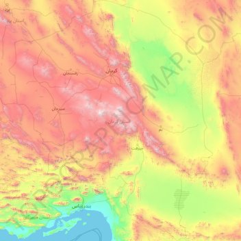
Name: Kerman Province topographic map, elevation, terrain.

Location: Kerman Province, Iran (26.44500 54.37031 31.95696 59.72550)

Average elevation: 1,150 m

Minimum elevation: -1 m

Maximum elevation: 4,224 m

Other topographic maps

Click on a map to view its topography, its elevation and its terrain.

Bojnord

Iran > North Khorasan Province > Bojnurd County

Average elevation: 1,090 m

Tehran

Iran > Tehran County

As the city has a large area, with significant differences in elevation among various districts, the weather is often cooler in the hilly north than in the flat southern part of Tehran. For instance, the 17.3 km (10.7 mi) Valiasr Street runs from Tehran's railway station at 1,117 m (3,665 ft) elevation above…

Average elevation: 1,539 m

Tirak

Iran > Damavand County > Abali RD

Average elevation: 2,351 m

Shiraz

Iran > Fars Province > Shiraz County

Shiraz's climate has distinct seasons, and is overall classed as a cold semi-arid climate (Köppen climate classification BSk), though it is only a little short of a hot semi-arid climate . Summers are hot, with a July average high of 37.9 °C (100.2 °F). Winters are cool, with average low temperatures below…

Average elevation: 1,785 m

Abhar City

Iran > Zanjan Province > Abhar County

Average elevation: 1,573 m

Isfahan

Iran > Isfahan Province > Isfahan County

Situated at 1,590 metres (5,217 ft) above sea level on the eastern side of the Zagros Mountains, Isfahan has a cold desert climate (Köppen BWk). No geological obstacles exist within 90 kilometres (56 miles) north of the city, allowing cool winds to blow from this direction. Despite its altitude, Isfahan…

Average elevation: 1,607 m

Sistan and Baluchestan Province

Iran

Average elevation: 763 m

Qom

Iran > Qom Province > Qom County

The city's topography in the 10th century still reflected the evolutionary merging of the original six villages; these were still separated by fields. The town center was located in the village of Mamajjān, which was connected to other parts of the city on the other side of the river by four bridges. There…

Average elevation: 943 m

Chaharmahal and Bakhtiyari Province

Iran

Average elevation: 2,064 m

Kermanshah Province

Iran

The province's capital is Kermanshah, located in the middle of the western part of Iran. The population of the city is 946,651 as of 2016. It is built on the slopes of Mt. Sefid Kooh and extended toward south during last two decades. The built-up areas run alongside Sarab River and Sarab Valley. The city's…

Average elevation: 1,369 m

Alborz Province

Iran

Average elevation: 1,756 m

Shahid Razavi

Iran > Razavi Khorasan > Mashhad County > Mashhad

Average elevation: 1,048 m

Shahriyar

Iran > Shahriar County

Average elevation: 1,151 m

Najaf Abad

Iran > Isfahan Province > Najafabad County

Average elevation: 1,712 m

Qir

Iran > Fars Province > Qir and Karzin County > Qir

Average elevation: 778 m

Kalat City

Iran > Razavi Khorasan > Kalat City

Average elevation: 965 m

Qom

Iran > Qom

The city's topography in the 10th century still reflected the evolutionary merging of the original six villages; these were still separated by fields. The town center was located in the village of Mamajjān, which was connected to other parts of the city on the other side of the river by four bridges. There…

Average elevation: 959 m

Isfahan

Iran > Isfahan

Average elevation: 1,605 m

Bushehr

Iran > Bushehr Province > Bushehr

Average elevation: 5 m

Khuzestan Province

Iran

Average elevation: 599 m

Namak Lake

Iran > Semnan Province > لجران

Average elevation: 817 m

Qeshm Island

Iran > Hormozgan Province > رمکان

Average elevation: 29 m

Esker

Iran > Kerman Province > Esker

Average elevation: 2,664 m

Urmia

Iran > West Azerbaijan Province > Urmia

Average elevation: 1,384 m