Geolocate

Cleveland topographic map

Click on the map to display elevation.

About this map

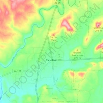
Name: Cleveland topographic map, elevation, terrain.

Location: Cleveland, Blount County, Alabama, United States (33.96439 -86.59658 34.02785 -86.54071)

Average elevation: 185 m

Minimum elevation: 124 m

Maximum elevation: 289 m

Other topographic maps

Click on a map to view its topography, its elevation and its terrain.

Sky Ball

United States > Alabama > Blount County

Average elevation: 276 m

Danzler

United States > Alabama > Blount County

Average elevation: 203 m

Brooksville

United States > Alabama > Blount County

Average elevation: 258 m

Little Warrior

United States > Alabama > Blount County

Average elevation: 180 m

Blount Springs

United States > Alabama > Blount County

Average elevation: 180 m

Bangor

United States > Alabama > Blount County

Average elevation: 193 m

Smoke Rise

United States > Alabama > Blount County > Hayden

Average elevation: 204 m

Oneonta

United States > Alabama > Blount County > Oneonta

Average elevation: 278 m

Snead

United States > Alabama > Blount County > Snead

Average elevation: 238 m

Mulberry Fork

United States > Alabama > Blount County

Average elevation: 172 m

Remlap

United States > Alabama > Blount County

Average elevation: 273 m

New Home

United States > Alabama > Blount County > New Home

Average elevation: 290 m

Cleveland

United States > Alabama > Blount County

Average elevation: 181 m