
Eysturoy region topographic map
Interactive map
Click on the map to display elevation.
About this map
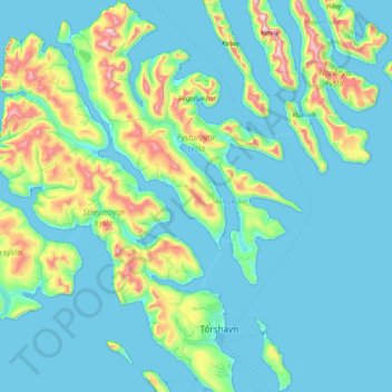
Name: Eysturoy region topographic map, elevation, terrain.
Location: Eysturoy region, Faroe Islands (61.94804 -7.11693 62.34124 -6.58892)
Average elevation: 130 m
Minimum elevation: -6 m
Maximum elevation: 878 m
Other topographic maps
Click on a map to view its topography, its elevation and its terrain.
Nes, Eysturoy
Faroe Islands > Eysturoy region
Nes, Eysturoy, Eysturoy region, 655, Faroe Islands
Average elevation: 33 m
Eysturoy
Faroe Islands > Eysturoy region > Skálabotnur
Eysturoy, Eysturoy region, Faroe Islands
Average elevation: 162 m