
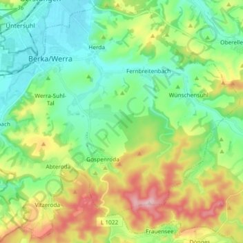
Berka/Werra topographic map
Interactive map
Click on the map to display elevation.
About this map
Name: Berka/Werra topographic map, elevation, terrain.
Average elevation: 284 m
Minimum elevation: 203 m
Maximum elevation: 453 m
Berka/Werra liegt im Zentrum des Berka-Gerstunger Beckens. Dieses weite Becken ist rings von Höhenzügen umgeben: im Südwesten der Seulingswald, im Süden die Ausläufer der Vorderrhön, im Osten die Ausläufer des Thüringer Waldes und im Norden das Richelsdorfer Gebirge. Geologisch betrachtet liegt der Ort in der geologischen Formation Trias, dem Mittleren Buntsandstein. Untertage befinden sich beträchtliche Kalisalzlagerstätten des Werra-Kalireviers, die früher im Schacht Alexandershall bei Dippach und Abteroda und bis heute bei Heringen abgebaut werden. Oberirdisch wurde beispielsweise am Hohe Rod und am Eichelberg Sandstein und Kies abgebaut.
Other topographic maps
Click on a map to view its topography, its elevation and its terrain.
Eisenach
Deutschland > Thüringen > Wartburgkreis
Eisenach, Wartburgkreis, Thüringen, 99817, Deutschland
Average elevation: 298 m
Krayenberggemeinde
Deutschland > Thüringen > Wartburgkreis
Krayenberggemeinde, Wartburgkreis, Thüringen, 36460, Deutschland
Average elevation: 305 m
Weilar
Deutschland > Thüringen > Wartburgkreis
Weilar, Dermbach, Wartburgkreis, Thüringen, 36457, Deutschland
Average elevation: 366 m
Milmesberg
Deutschland > Thüringen > Wartburgkreis
Milmesberg, Gerstungen, Wartburgkreis, Thüringen, 99848, Deutschland
Average elevation: 373 m
Ramsberg
Deutschland > Thüringen > Wartburgkreis > Lauterbach
Ramsberg, Lauterbach, Hainich-Werratal, Wartburgkreis, Thüringen, 99826, Deutschland
Average elevation: 324 m
Hötzelsroda
Deutschland > Thüringen > Wartburgkreis > Eisenach
Hötzelsroda, Eisenach, Wutha-Farnroda, Wartburgkreis, Thüringen, 99817, Deutschland
Average elevation: 295 m
Scherbda
Deutschland > Thüringen > Wartburgkreis
Scherbda, Amt Creuzburg, Hainich-Werratal, Wartburgkreis, Thüringen, 99830, Deutschland
Average elevation: 338 m
Dermbach
Deutschland > Thüringen > Wartburgkreis
Dermbach, Wartburgkreis, Thüringen, 36466, Deutschland
Average elevation: 446 m
Mihla
Deutschland > Thüringen > Wartburgkreis
Mihla, Amt Creuzburg, Hainich-Werratal, Wartburgkreis, Thüringen, 99831, Deutschland
Average elevation: 306 m
Moorgrund
Deutschland > Thüringen > Wartburgkreis > Bad Salzungen
Moorgrund, Bad Salzungen, Wartburgkreis, Thüringen, Deutschland
Average elevation: 358 m
Deicheroda
Deutschland > Thüringen > Wartburgkreis > Unterbreizbach
Deicheroda, Unterbreizbach, Wartburgkreis, Thüringen, 36404, Deutschland
Average elevation: 412 m
Nazza
Deutschland > Thüringen > Wartburgkreis
Nazza, Hainich-Werratal, Wartburgkreis, Thüringen, Deutschland
Average elevation: 345 m
Ettmarshausen
Deutschland > Thüringen > Wartburgkreis > Barchfeld-Immelborn
Ettmarshausen, Immelborn, Barchfeld-Immelborn, Wartburgkreis, Thüringen, 36456, Deutschland
Average elevation: 269 m
Auf der
Deutschland > Thüringen > Wartburgkreis > Dermbach > Stadtlengsfeld
Auf der, Stadtlengsfeld, Dermbach, Wartburgkreis, Thüringen, 36466, Deutschland
Average elevation: 332 m
Völkershausen
Deutschland > Thüringen > Wartburgkreis > Vacha
Völkershausen, Vacha, Wartburgkreis, Thüringen, 36404, Deutschland
Average elevation: 392 m
Spahl
Deutschland > Thüringen > Wartburgkreis > Geisa
Spahl, Geisa, Wartburgkreis, Thüringen, Deutschland
Average elevation: 431 m
Brückenberg
Deutschland > Thüringen > Wartburgkreis > Nazza
Brückenberg, Nazza, Hainich-Werratal, Wartburgkreis, Thüringen, 99826, Deutschland
Average elevation: 327 m
Rabenberg
Deutschland > Thüringen > Wartburgkreis > Hörselberg-Hainich
Rabenberg, Hörselberg-Hainich, Wartburgkreis, Thüringen, 99848, Deutschland
Average elevation: 423 m
Wittgenstein
Deutschland > Thüringen > Wartburgkreis > Wutha-Farnroda
Wittgenstein, Wutha-Farnroda, Wartburgkreis, Thüringen, 99848, Deutschland
Average elevation: 333 m
Bad Salzungen
Deutschland > Thüringen > Wartburgkreis
Bad Salzungen, Wartburgkreis, Thüringen, Deutschland
Average elevation: 347 m
Steinkopf
Deutschland > Thüringen > Wartburgkreis > Eisenach
Steinkopf, Eisenach, Wartburgkreis, Thüringen, 99848, Deutschland
Average elevation: 308 m
Kittelsthal
Deutschland > Thüringen > Wartburgkreis > Ruhla
Kittelsthal, Ruhla, Wartburgkreis, Thüringen, 99848, Deutschland
Average elevation: 367 m
Pfaffenkopf
Deutschland > Thüringen > Wartburgkreis > Treffurt
Pfaffenkopf, Treffurt, Wartburgkreis, Thüringen, Deutschland
Average elevation: 297 m
Bauernberg
Deutschland > Thüringen > Wartburgkreis > Hörselberg-Hainich
Bauernberg, Hörselberg-Hainich, Wutha-Farnroda, Wartburgkreis, Thüringen, 99848, Deutschland
Average elevation: 344 m
Abendsberg
Deutschland > Thüringen > Wartburgkreis > Geisa > Wiesenfeld
Abendsberg, Wiesenfeld, Geisa, Wartburgkreis, Thüringen, 36419, Deutschland
Average elevation: 333 m
Weißer Stein
Deutschland > Thüringen > Wartburgkreis > Bad Liebenstein
Weißer Stein, Bad Liebenstein, Wartburgkreis, Thüringen, 36448, Deutschland
Average elevation: 553 m
Ruhla
Deutschland > Thüringen > Wartburgkreis
Ruhla, Wartburgkreis, Thüringen, 99842, Deutschland
Average elevation: 495 m
Etterwinden
Deutschland > Thüringen > Wartburgkreis > Bad Salzungen
Etterwinden, Bad Salzungen, Wartburgkreis, Thüringen, Deutschland
Average elevation: 406 m
Treffurt
Deutschland > Thüringen > Wartburgkreis
Treffurt, Wartburgkreis, Thüringen, 99830, Deutschland
Average elevation: 303 m
Hirschkopf
Deutschland > Thüringen > Wartburgkreis > Eisenach
Hirschkopf, Eisenach, Wutha-Farnroda, Wartburgkreis, Thüringen, 99848, Deutschland
Average elevation: 279 m
Lenders
Deutschland > Thüringen > Wartburgkreis > Oechsen > Lenders
Lenders, Oechsen, Dermbach, Wartburgkreis, Thüringen, Deutschland
Average elevation: 549 m
Ettenhausen an der Nesse
Deutschland > Thüringen > Wartburgkreis > Hörselberg-Hainich > Ettenhausen an der Nesse
Ettenhausen an der Nesse, Hörselberg-Hainich, Wutha-Farnroda, Wartburgkreis, Thüringen, 99848, Deutschland
Average elevation: 310 m
Ettenhausen a.d. Suhl
Deutschland > Thüringen > Wartburgkreis > Bad Salzungen > Ettenhausen a.d. Suhl
Ettenhausen a.d. Suhl, Bad Salzungen, Wartburgkreis, Thüringen, Deutschland
Average elevation: 296 m
Merkers
Deutschland > Thüringen > Wartburgkreis
Merkers, Krayenberggemeinde, Wartburgkreis, Thüringen, 36460, Deutschland
Average elevation: 292 m
Eisborn
Deutschland > Thüringen > Wartburgkreis > Bad Liebenstein
Eisborn, Bad Liebenstein, Wartburgkreis, Thüringen, 36488, Deutschland
Average elevation: 416 m
Observation Point India
Deutschland > Thüringen > Wartburgkreis > Treffurt > Ifta
Observation Point India, Kolonnenweg, Ifta, Treffurt, Wartburgkreis, Thüringen, 99830, Deutschland
Average elevation: 333 m
Seebach
Deutschland > Thüringen > Wartburgkreis > Seebach
Seebach, Ruhla, Wartburgkreis, Thüringen, 99846, Deutschland
Average elevation: 395 m
Creuzburg
Deutschland > Thüringen > Wartburgkreis
Creuzburg, Amt Creuzburg, Hainich-Werratal, Wartburgkreis, Thüringen, Deutschland
Average elevation: 295 m
Hörschel
Deutschland > Thüringen > Wartburgkreis > Eisenach > Hörschel
Hörschel, Eisenach, Wartburgkreis, Thüringen, 99819, Deutschland
Average elevation: 255 m
Hüneburg
Deutschland > Thüringen > Wartburgkreis > Treffurt
Hüneburg, Treffurt, Wartburgkreis, Thüringen, 99830, Deutschland
Average elevation: 341 m
Hörselberg-Hainich
Deutschland > Thüringen > Wartburgkreis > Hörselberg-Hainich > Hörselberg-Hainich
Hörselberg-Hainich, Wutha-Farnroda, Wartburgkreis, Thüringen, 99848, Deutschland
Average elevation: 329 m
Deubach
Deutschland > Thüringen > Wartburgkreis > Wutha-Farnroda > Deubach
Deubach, Wutha-Farnroda, Wartburgkreis, Thüringen, 99848, Deutschland
Average elevation: 339 m
Hausbreitenbach
Deutschland > Thüringen > Wartburgkreis > Hausbreitenbach
Hausbreitenbach, Werra-Suhl-Tal, Wartburgkreis, Thüringen, 99837, Deutschland
Average elevation: 242 m
Bad Liebenstein
Deutschland > Thüringen > Wartburgkreis
Bad Liebenstein, Wartburgkreis, Thüringen, 36448, Deutschland
Average elevation: 424 m
Gerstungen
Deutschland > Thüringen > Wartburgkreis
Gerstungen, Wartburgkreis, Thüringen, 99834, Deutschland
Average elevation: 302 m
Behringen
Deutschland > Thüringen > Wartburgkreis > Hörselberg-Hainich > Behringen
Behringen, Hörselberg-Hainich, Wutha-Farnroda, Wartburgkreis, Thüringen, 99848, Deutschland
Average elevation: 303 m
Wutha-Farnroda
Deutschland > Thüringen > Wartburgkreis > Wutha-Farnroda
Wutha-Farnroda, Wartburgkreis, Thüringen, 99848, Deutschland
Average elevation: 351 m
Stadtlengsfeld
Deutschland > Thüringen > Wartburgkreis > Dermbach
Stadtlengsfeld, Dermbach, Wartburgkreis, Thüringen, Deutschland
Average elevation: 385 m
Gehaus
Deutschland > Thüringen > Wartburgkreis > Dermbach
Gehaus, Dermbach, Wartburgkreis, Thüringen, Deutschland
Average elevation: 437 m
Melborn
Deutschland > Thüringen > Wartburgkreis
Melborn, Hörselberg-Hainich, Wartburgkreis, Thüringen, 99820, Deutschland
Average elevation: 303 m