
Thank you for supporting this site ❤️
Make a donation
Make a donation
Le Cluset topographic map
Click on the map to display elevation.
Thank you for supporting this site ❤️
Make a donation
Make a donation
About this map
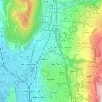
Name: Le Cluset topographic map, elevation, terrain.
Average elevation: 356 m
Minimum elevation: 231 m
Maximum elevation: 630 m
Thank you for supporting this site ❤️
Make a donation
Make a donation
Other topographic maps
Click on a map to view its topography, its elevation and its terrain.
Château de la Roche du Roi
France > Auvergne-Rhône-Alpes > Savoie > Aix-les-Bains
Average elevation: 303 m