Geolocate

Sardinia topographic map

Click on the map to display elevation.

Sardinia

The climate of the island is variable from area to area, due to several factors including the extension in latitude and the elevation. It can be classified in two different macrobioclimates (Mediterranean pluviseasonal oceanic and Temperate oceanic), one macrobioclimatic variant (Submediterranean), and four classes of continentality (from weak semihyperoceanic to weak semicontinental), eight thermotypic horizons (from lower thermomediterranean to upper supratemperate), and seven ombrotypic horizons (from lower dry to lower hyperhumid), resulting in a combination of 43 different isobioclimates.

Wikipedia (CC-BY-SA 3.0)

About this map

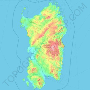
Name: Sardinia topographic map, elevation, terrain.

Location: Sardinia, Italy (38.85908 8.13084 41.31311 9.82932)

Average elevation: 109 m

Minimum elevation: -2 m

Maximum elevation: 1,813 m

Other topographic maps

Click on a map to view its topography, its elevation and its terrain.

Bertolini

Italy > Piedmont > Cuneo > Crissolo

Average elevation: 1,686 m

Tassara

Italy > Emilia-Romagna > Parma > Lesignano de' Bagni

Average elevation: 310 m

Pietrabuona

Italy > Tuscany > Pistoia > Pescia

Average elevation: 373 m

Brignole

Italy > Liguria > Genoa > Rezzoaglio

Average elevation: 951 m

Vara Inferiore

Italy > Liguria > Savona

Average elevation: 793 m

Bestagno

Italy > Liguria > Provincia di Imperia > Pontedassio

Average elevation: 274 m

Salice Terme

Italy > Lombardy > Pavia > Godiasco Salice Terme

Average elevation: 221 m

Pracchia

Italy > Tuscany > Pistoia > Pistoia

Average elevation: 837 m

Forno di Zoldo

Italy > Veneto > Belluno

Average elevation: 1,126 m

Santa Maria

Italy > Liguria > La Spezia > Calice al Cornoviglio

Average elevation: 609 m

Casalbagliano

Italy > Piedmont > Alessandria > Alessandria

Average elevation: 96 m

Ravizza

Italy > Piedmont > Biella > Andorno Micca

Average elevation: 683 m

Cave del Predil

Italy > Friuli – Venezia Giulia > Udine > Tarvisio

Average elevation: 1,320 m

Albese

Italy > Lombardy > Como > Albese con Cassano

Average elevation: 481 m

Polverara

Italy > Liguria > La Spezia

Average elevation: 274 m

Etna

Italy > Sicily > Catania > Zafferana Etnea

Eruptions of Etna follow multiple patterns. Most occur at the summit, where there are five distinct craters: the Northeast Crater, the Voragine, the Bocca Nuova, and two at the Southeast Crater Complex. Other eruptions occur on the flanks, which have more than 300 vents ranging in size from small holes in the…

Average elevation: 2,976 m

Biestro

Italy > Liguria > Savona > Pallare

Average elevation: 581 m

Precicchie

Italy > Ancona > Fabriano

Average elevation: 493 m

Ponzò

Italy > Liguria > La Spezia > Riccò del Golfo di Spezia

Average elevation: 276 m

Abasse

Italy > Piedmont > Alessandria > Ponzone

Average elevation: 621 m

Perleto

Italy > Piedmont > Alessandria > Carezzano

Average elevation: 308 m

Capodipiano

Italy > Marche > Ascoli Piceno > Venarotta > Arola

Average elevation: 416 m

Monastero

Italy > Piedmont > Cuneo > Mondovì

Average elevation: 448 m

Montalto Ligure

Italy > Liguria > Provincia di Imperia

Average elevation: 529 m

Saturnia

Italy > Tuscany > Grosseto

Average elevation: 182 m

Sella Nevea

Italy > Friuli – Venezia Giulia > Udine > Chiusaforte

Sella Nevea (Friulian: Nevee, German: Neveasattel, Slovene: Na Žlebeh), at an altitude of 1,195 m (3,921 ft), is a high mountain pass in the Julian Alps, in the Friuli-Venezia Giulia region of northeast Italy. Sella Nevea also lends its name to a frazione of the Chiusaforte municipality and the nearby…

Average elevation: 1,545 m

Canegreca

Italy > Liguria > La Spezia > Carrodano

Average elevation: 460 m

Rossano

Italy > Calabria > Cosenza

Average elevation: 265 m

Ponte a Bozzone

Italy > Tuscany > Siena

Average elevation: 281 m

Mestre

Italy > Veneto > Venezia > Venice

Average elevation: 4 m

Monteacuto

Italy > Lombardy > Brescia > Palude

Average elevation: 198 m

Montescotto

Italy > Piedmont > Cuneo > Barge

Average elevation: 643 m

Montignano-Marzocca

Italy > Marche > Ancona > Senigallia

Average elevation: 26 m

Pievetta

Italy > Piedmont > Cuneo

Average elevation: 735 m

Cellio

Italy > Piedmont > Vercelli > Cellio con Breia

Average elevation: 691 m

Trappa

Italy > Aosta Valley > Courmayeur

Average elevation: 1,861 m

Serta

Italy > Lombardy > Bergamo > Schilpario

Average elevation: 1,426 m

Perda Canuda

Italy > Sardinia > Casteddu/Cagliari > Seui

Average elevation: 994 m

Vara Superiore

Italy > Liguria > Savona

Average elevation: 819 m

Fratta Terme

Italy > Emilia-Romagna > Bertinoro

Average elevation: 81 m

Costa

Italy > Basilicata > Matera > Garaguso

Average elevation: 434 m

Cireglio

Italy > Tuscany > Pistoia > Pistoia

Average elevation: 589 m

Giuliano di Lecce

Italy > Apulia > Lecce

Average elevation: 132 m

Faggeto Beach

Italy > Lombardy > Como > Faggeto Lario > Molina > Riva

Average elevation: 363 m

Cielo Alto

Italy > Aosta Valley > Le Breuil - Cervinia

Average elevation: 2,333 m

Santa Chiara

Italy > Tuscany > Siena > San Gimignano

Average elevation: 255 m

Prestine

Italy > Lombardy > Brescia

Average elevation: 780 m

Tre Cime di Lavaredo - Drei Zinnen

Italy > Veneto > Belluno > Auronzo di Cadore

Until 1919 the peaks formed part of the border between Italy and Austria-Hungary. Now they lie on the border between the Italian provinces of South Tyrol and Belluno and still are a part of the linguistic boundary between German-speaking and Italian-speaking majorities. The Cima Grande has an elevation of…

Average elevation: 2,242 m

Colli Lilli

Italy > Lazio > Roma Capitale > Castel Gandolfo

Average elevation: 211 m

San Marco

Italy > Campania > Salerno

Average elevation: 73 m

La Casa

Italy > Tuscany > Arezzo > San Clemente in Valle

Average elevation: 725 m

Castellazzo

Italy > Piedmont > Alessandria

Average elevation: 199 m

Medici

Italy > Campania > Caserta > Formicola

Average elevation: 341 m

Senni

Italy > Tuscany > Florence

Average elevation: 218 m

Marangi

Italy > Apulia > Lecce > Lecce

Average elevation: 32 m

Agro

Italy > Lombardy > Bergamo

Average elevation: 924 m

Pianche

Italy > Piedmont > Cuneo

Average elevation: 1,496 m

Stramare

Italy > Veneto > Treviso > Segusino

Average elevation: 618 m

La battaglia del Monte Castello

Italy > Emilia-Romagna > Bologna > Abetaia

Monte Castello is a hill located about 48 km (30 mi) north of Pistoia (Tuscany) and 60 km (37 mi) southwest of Bologna (Emilia-Romagna), via Località Abetaia (SP623), near Abetaia di Gaggio Montano, coordinates 44.221799, 10.954227, at 977 m (3,205 ft) altitude, in the Northern Apennines. on the border…

Average elevation: 845 m

San Bernolfo

Italy > Piedmont > Cuneo > Vinadio

Average elevation: 2,036 m

Tarderia

Italy > Sicily > Catania > Pedara

Average elevation: 924 m

Monte Testaccio

Italy > Lazio > Rome

Average elevation: 35 m

Assergi

Italy > Abruzzo > L'Aquila > Assergi

Average elevation: 1,035 m

Badia al Pino

Italy > Tuscany > Badia al Pino

Average elevation: 284 m

Magliano

Italy > Tuscany > Magliano

Average elevation: 902 m

Ragusa

Italy > Sicily > Ragusa > Ragusa

Average elevation: 366 m

Marina di Ragusa

Italy > Sicily > Ragusa > Ragusa > Marina di Ragusa

Average elevation: 33 m

Genoa

Italy > Liguria > Genoa > Genoa

The city of Genoa covers an area of 243 square kilometres (94 sq mi) between the Ligurian Sea and the Apennine Mountains. The city stretches along the coast for about 30 kilometres (19 mi) from the neighbourhood of Voltri to Nervi, and for 10 kilometres (6.2 mi) from the coast to the north along the valleys…

Average elevation: 247 m

Bigolino

Italy > Veneto > Treviso > Valdobbiadene

Average elevation: 168 m

Timau

Italy > Friuli-Venezia Giulia > Udine

Average elevation: 1,307 m