
Provincia de Maipo topographic map
Interactive map
Click on the map to display elevation.
About this map
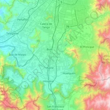
Name: Provincia de Maipo topographic map, elevation, terrain.
Location: Provincia de Maipo, Santiago Metropolitan Region, Chile (-33.98839 -70.98889 -33.52398 -70.47520)
Average elevation: 829 m
Minimum elevation: 244 m
Maximum elevation: 3,070 m
Other topographic maps
Click on a map to view its topography, its elevation and its terrain.
Chicureo
Chile > Santiago Metropolitan Region > Provincia de Chacabuco > Colina
Average elevation: 711 m
Montenegro
Chile > Santiago Metropolitan Region > Provincia de Chacabuco > Tiltil
Average elevation: 836 m
Rinconada
Chile > Santiago Metropolitan Region > Provincia de Talagante > El Monte > El Paico Alto
Average elevation: 445 m