
Thank you for supporting this site ❤️
Make a donation
Make a donation
Togdheer topographic map
Click on the map to display elevation.
Thank you for supporting this site ❤️
Make a donation
Make a donation
About this map
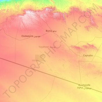
Name: Togdheer topographic map, elevation, terrain.
Location: Togdheer, Somaliland, Somalia (8.00074 44.69000 10.09882 47.10000)
Average elevation: 905 m
Minimum elevation: 179 m
Maximum elevation: 1,978 m
Thank you for supporting this site ❤️
Make a donation
Make a donation
Other topographic maps
Click on a map to view its topography, its elevation and its terrain.