
Wahkiakum County topographic map
Interactive map
Click on the map to display elevation.
About this map
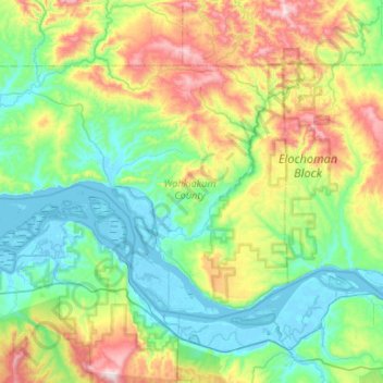
Name: Wahkiakum County topographic map, elevation, terrain.
Location: Wahkiakum County, Washington, United States of America (46.14463 -123.74008 46.38551 -123.21267)
Average elevation: 246 m
Minimum elevation: -3 m
Maximum elevation: 918 m
Other topographic maps
Click on a map to view its topography, its elevation and its terrain.
SeaTac
United States of America > Washington > SeaTac
SeaTac, King County, Washington, United States of America
Average elevation: 60 m
Bellevue
United States of America > Washington > Bellevue
Bellevue, King County, Washington, 98004-4452, United States of America
Average elevation: 88 m
Bellingham
United States of America > Washington > Bellingham
Bellingham, Whatcom County, Washington, United States of America
Average elevation: 89 m
Yakima
United States of America > Washington > Yakima
Yakima, Yakima County, Washington, United States of America
Average elevation: 377 m
Lewis County
United States of America > Washington
Lewis County, Washington, United States of America
Average elevation: 558 m
Okanogan County
United States of America > Washington
Okanogan County, Washington, United States of America
Average elevation: 1,076 m
Clallam County
United States of America > Washington
Clallam County, Washington, United States of America
Average elevation: 335 m
Thurston County
United States of America > Washington
Thurston County, Washington, United States of America
Average elevation: 150 m